Mapping Change

with Sarah Workneh and Caroline Woolard

October 4, 2013

When I met Caroline and Sarah at the end of Java Street on Friday morning,

we didn’t have much of a map,

just a plan to see some of the prettiest coastline in New York City.

We set our date months ago, and it couldn’t have fallen on a prettier day.

I knew that Sarah was a little apprehensive about the water,

so I paid careful attention to the traffic.

But when she calmly watched a huge DEP ship roll past,

I knew we it would be smooth sailing.

“New York looks great from the water,” said Sarah. “just like it does on television!”

Our first stop was Roosevelt Island.

Sarah had never been there before, so it seemed fitting to come by water.

We were caught landing by park employees. “The park is closed!” they said. “Stay on the other side of the fence!”

When you come by water, it’s hard to tell which side of the fence is ‘other’,

so we wandered happily between the fences for a while, thinking that our blue life jackets made us look like park employees anyhow.

Soon the water called us back,

and we headed up the East River with the incoming tide.

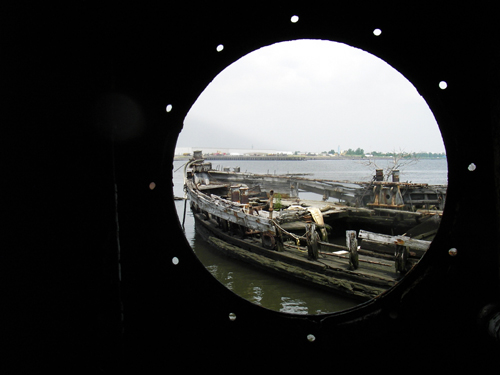
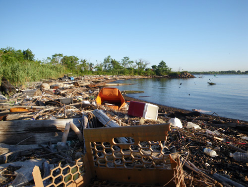
Our next destination was Milrock Island, an abandoned stretch of land,

just past the northern tip of Roosevelt Island.

It was man-made in 1885 from rocks cleared out of the Hell’s Gate shipping channel.

“An island’s island.” said Caroline.

There is a story in ‘Other Islands of New York City’ about a group of school children who landed on the island in the 1950’s and were attacked by rats.

We saw one, but I was so excited that I fumbled with my camera and didn’t get its picture.

The rat was of a strange variety, almost like a nutria, or an islandized descendant of the children-eating ones…

living just on bones.

I told Sarah and Caroline about a video I want to make where a group of women survive armageddon by living on islands in New York City.

Caroline told us about the Greenham Common Women’s Peace Camp, an all-female commune established to protest nuclear weapons in 1981.

The protest lasted 19 years, and helped bring about legislation that removed Cruise Missiles from the Greenham Common Airbase.

Caroline said that the camp was divided into skill groups. “There were sections for artists, cooks, and a whole group of women who’s job it was just to interact with the police.”

“I want to be in the group that deals with the cops.” said Sarah.

I figured we would all just be in the art section, but actually, Sarah would be great on the front lines.

She is the director of an art residency where I worked this summer, and her demeanor is perfect;

fair, strong, and protective of her brood.

Meanwhile, we were coming up to a spot that Caroline wanted to check out.

From the street it looks like a little brick castle, nestled between a bridge and power plant. This would be a perfect home for Caroline’s next community land trust experiment.

“You can’t really get to it from here.” said Caroline.

“We’ll have to come back by land.” I said.

We pulled up at Anable Basin,

to find something to eat.

They weren’t serving sausages this early in the morning, but there was plenty of beer.

We talked for almost an hour, hatching a plan to redirect the mission of ‘Kickstarter’ to actually change the world.

“You see,” said Caroline, “the system can’t change if people still want private property.”

“Real change can only come with public ownership; a return to the commons.”

Caroline doesn’t just say stuff like that either, her life’s work is about it.

With projects like Trade School and OurGoods, she has worked to put her beliefs into practice on a large scale.

The tide was moving fast now and we were being delivered back to our launching point,

past a group of cormorants,

past the Huron Street Piers.

“Be sure and tell us when you make your video about the women who survive the end of the world!” said Caroline and Sarah.

“We want to be in it!”

“You already are.” I thought.

Treasure Map

with Essye Klempner and Beverly Acha

September 6, 2013

Essye’s wanted to visit the area around Bottle Beach and try to figure out where things were in relation to some old maps.

Since March, she had been sending me maps, and it was amazing to see the places that I knew so well covered in water.

We set out from a pretty little beach at the end of Gerritsen Avenue.

This would have been the site of a dozens horse rendering plants in the 1850’s.

My idea was to let ourselves be washed out into the bay by the tide. We would travel just like the all the horse parts that were dumped here 150 years ago.

But once we got out into the Plum Beach Channel, we just wanted to paddle and explore.

The sun was just coming up in the marina,

and it was a pleasure to float quietly by the houses.

We even found one for rent,

and saw some of the effects of Hurricane Sandy.

Ghostly wrecks extended silently into the water under our boat.

It was turning into a pretty day, filled with contrasts.

The sky was like a painting.

I wanted to visit White Island, part of the Gerritsen Marine Park that was made from landfill in 1917.

On old maps of the area, it is just an unnamed bit of shifting sand,

but now it has a name, a solid shore, a wikipedia entry,

and a fine view of One World Trade Center.

The whole island is part of a New York City Parks Department regeneration project to bring back native birds and plants.

Little sprigs of delicate sea grass were shooting up in even rows.

There was someone else enjoying the fresh shoots though, before any human visitors could see them.

The island was covered with small fuzzy cocoons.

It was great to be out with two artists who liked to look at everything so closely.

For a long time we watched a strange formation of oil and sand float by the coast of the island.

There was something about the way the light clung to the edges of these forms that looked like a computer generated image,

or like something Beverly would paint.

It was time to push off.

We passed by dense, healthy stands of invasive phragmites. I couldn’t help but think that in a few years, the moths will wipe out the native grass on White Island and this stuff will be all thats left.

It is hard not to admire the unloved weed, happy to step in when others fail.

The wind was pushing us along well,

and in no time we were out under the Belt Parkway,

moving into Dead Horse Bay just like all those horse parts in the 1850’s.

The shore of Barren Island lay ahead,

another landfill island and the site of New York City’s very first airport.

The shore of Barren Island is famously awash with bottles from the 1920’s that erode out of the landfill there.

We paddled close to the shore of ‘Bottle Beach’.

The wind pushed us at a perfect pace,

it was like beach combing from the boat,

but Essye wanted to get a closer look.

Our mission was not just to observe the beach.

Just before the Marine Parkway Bridge,

we pulled the boat ashore.

The tide was in, but there was still plenty of stuff to see.

We imediatly began to find the bones of the old rendering plants,

and the bottles that make this beach famous.

We felt like archeologists, digging up the not-so-distant past.

Nothing seemed to paint a picture of the 1920’s better than this perfume pump that Beverly found,

or this medicine bottle with the directions still visible.

It was fun to see interlopers from the present too,

like strange ghosts living in the ruins of a lost civilization.

As we rounded the peninsula, we found somehting amazing.

Hurricane Sandy had taken off another few feet of shore, to revealed huge chunks of the actual landfill.

It formed dense walls of silk stockings, bottles, shoe parts, fabric…

As we picked through the debris with sticks, I fought back a wave of revulsion.

There was something scary about digging into this hundred year old trash,

perhaps it was possible to uncover the evidence of a long ago crime.

We weren’t the only contemporary folks who had been exploring the landfill.

Bottle Beach is a famous site, and people come here often to collect things that our forbearers dumped,

or leave it behind again in pretty arrangements.

We stopped to look at everything we had collected.

“If we were Gabriel Orozco, we’de be done right now.” said Essye.

But we weren’t done. We had a few miles to travel to get back to my truck.

The wind changed direction and it was possible to row back instead of ride my bike.

It was still morning, but we felt like a century had passed since we were on this beach at sunrise.

Thank you Beverly and Essye for a great day of treasure hunting!

Freedom / Captivity

with Lisa Sigal

September 5, 2013

When we drove to the area in Throgs Neck that I thought might be a good place to put the boat in the water, we were met with nothing but fences and private property.

The only access seemed to be at a middle-school that was still closed for summer vacation.

They had a pretty little beach right on the East River,

and an unlocked fence,

so I reparked the car while Lisa waited with the boat.

“This will all be legal once we get out on the water.” I told Lisa,

and in no time we were floating away, under the Whitestone Bridge.

“I’ve never done anything like this before.” said Lisa.

I hadn’t either, to be honest. This was the first time my new boat had been out in the East River, and it was being put to the test in the fast current.

You could see Manhattan in the distance,

and huge barges moved out in the shipping channel.

We were about to cross the mouth of the Bronx River, a mile long expanse of open water.

“Are you ok with this?” I asked.

“Sure!” said Lisa. She was in full observation mode now,

and Hunt’s Point was coming into view.

We passed a huge abandoned dry-dock,

and I listened to the water being sucked through it’s pilings like a whale’s mouth.

Around the leeward side of the dry-dock, we pulled up to take a break.

Lisa tied our bow to the dock,

and produced amazing sandwiches for lunch.

Now it was time to set out for our real mission,

the Vernon C. Bain Correctional Center.

Lisa came across it when she was researching prisons in New Orleans. That’s where this thing was made.

It was brought to New York City in 1992 to help overcrowding at Rikers Island.

When Lisa told me about it, I imagined a British ‘Prison Hulk’. That was the name for the decommissioned naval vessels that were used to house inmates in the 18th century.

But the Vernon C. is a state-of-the-art prison facility,

complete with a gym, library, 16 dormitory style rooms and 100 cells. It even has an outdoor basketball court.

There seemed to be some chinks in the armor though, like this stray piece of razor wire hanging oddly from the basketball court.

Also, the whole thing seemed to be listing, ever so slightly, to the starbord side.

This observation seemed confirmed when we saw a crew come out and dangle a tape measure over the side of the boat. Were they meassuring the distance from the water on one side to see if it was different from the other?

Could the Vernon C. Bain Correctional Center be sinking?

The current was swelling, wave after wave pushing us away from the prison barge,

and a huge storm cloud moved past.

Pockets of still water appeared in the current. “Upwelling,” I told Lisa, “water being pushed up from the bottom of the East River.” It was a sign that the current was still flowing strong to the south, and we needed a north flowing tide for our ride back.

We decided to pull over and wait for the tide to turn around at North Brother Island.

No sooner had we pointed our boat in the direction of North Brother, than we were stopped by the Coast Guard.

“Don’t land on that island,” they said. “It’s dangerous.”

What could be dangerous about a deserted island, we wondered. The prisons, hospitals, and reform schools on North Brother have all been abandoned since the 1960’s.

We decided to take our chances,

and pulled up the boat to wait.

We talked about how water is used as a barrier; phycological as well as practical.

Rikers Island, North Brother Island, and the prison barge, have all had been used at one time or another as a place to keep people away from other people.

Lisa is an artist, and she makes sculpture about how ideas present themselves in the built environment. Her artwork pokes at the distinction between open space, private space, captive space and free space. The water can be all those things, I thought, both a road and a barrier.

We could see the tide turning out in the bay,

so we decided to make a run for it.

The storm cloud had past and it was turning into a windy, sunny day.

The problem was, it was windy in the wrong direction.

The tide was helping us north but the wind was much stronger against us,

and we couldn’t make any headway.

Ironically, we were being held right in between Rikers Island and the prison barge.

We decided to turn around and try to paddle with the wind.

I had seen a little beach back on the Bronx waterfront,

and we pulled the boat out of the water.

The beach was on a deserted stretch,

of the pretty little Borretto Point Park.

We had miles of buses, trains, and walking between us and the car,

and what had seemed like a breeze by boat was harder by land.

These are the nether regions of New York City, the back end of commerce, populated by trucks and traintracks with almost no humans in sight.

I can tell you that if you have to explore a rough place lime this, Lisa would be a good partner for you.

She is efficient, happy to walk, and she brings along good snacks.

It took us longer to get back north than it had to come south by water,

but soon we had reunited all our modes of transportation.

Aerial Map

with Iben Wirth Carlsen and Kristian Blomstroem Johansson

August 28, 2013

I met Iben and Kristian on the Gowanus Canal at sunrise.

They were visiting New York from Copenhagen, and they were staying just a few blocks from the canal.

It was fun to explore the area with them.

Kristian participated in the summer program where I was teaching this summer. He was one of the stalwart campers who made a two day, 60 mile boat ride down the Kennebec River.

Kristian was always exploring while we were on that trip. He would disappear for hours to wander the interior while the rest of us stayed on the river bank.

Iben seemed like a perfect match.

We looked at the mile of fences surrounding the site of the future Whole Foods grocery store.

There seemed to be some new development across the canal,

and even new bird houses to match.

But for the most part, the Gowanus seemed like it always does;

like a forgotten doorway into a secret world;

like finding a hatch at the back of your closet and wandering through.

We came to a part of the canal where oil wells up out of the ground, or is dumped continually by the tugs that move the salvage barge.

Our boat cut a path through the oil.

I asked Iben and Kristian if the waterways in Europe were so polluted,

but it was hard to compare.

“We’ll be out of here soon.” I told them.

“There is something American for you,” I thought as we passed the salvage yard,

“a huge pile of garbage and a billboard saying nothing.”

I guess what is different about pollution in the Gowanus (compared to Europe) is how much we accomplished in such a short period of time.

Soon we were in the clear air of the bay,

and it was time to get to work.

I had Kristian and Iben take over piloting the boat,

while I got our supplies ready.

I had purchased a kit from Public Lab to take an aerial image of the canal.

They have a project to try and stitch together images that people take of their neighborhoods and surroundings – like a people’s map of the world.

Maybe we could add a small section of the Gowanus to the Public Lab’s map.

We filled up the balloon,

attached the camera,

and let out the line.

It was a busy day out in the open bay,

and huge tug boats were moving all around us.

We looked up at the balloon and imagined all the things it must be seeing from up there…

or was it even seeing anything?

The truth was somewhere in between.

The camera picked up images of the water as it spun and swirled in the wind.

Once in a while, we came into view,

paddling along, then spinning out of focus.

Mostly the camera seemed to focus on reflections of itself in the water; self centered, just like us.

At one point someone on shore was taking a picture of us, while we were taking a picture of the balloon, while it was taking a picture of the boat.

“There are now at least three images of this completely banal moment.” I said.

Most of the shots out in the bay were out of focus. We had not let out enough line for the camera to see the shore.

We had to reel the camera in to get back under a bridge,

and when we let it out again, something interesting began to happen.

We entered the area of the oil slick,

and finally, the balloon camera had something to focus on.

The surface of the water was alive and shimmering with color.

We inched through the spill,

our eye in the sky tugging gently on the line.

There was something animate about the way it wandered around on its own and looked down at us.

“It feels like we have a pet.” Said Iben.

Iben had her hand on the cord, and we urged her to let it out further so that it could see more.

The balloon tugged upwards,

away from the canal,

up above the cement factory,

and the future site of the Whole Foods grocery store,

Before the last bridge, we tugged it down and took the balloon back into the boat.

We would not see what the camera had seen until I got back home to my computer that night,

and Kristian and Iben were heading back to Copenhagen the next day.

For now, it was fun to speculate.

Jasper’s Map

With Jasper Harvest Kim-Witthoft, Eunice Kim, and Debbie Tuch

August 26, 2013

When Jasper Harvest Kim-Witthoft found out that she was going out in the boat on Wednesday, she got right to work on her map.

“She always sees us looking at maps on our phones,” said Jasper’s mom. “It’s funny how quickly she learned to visualize space that way.”

I had never taken someone so small out in the boat before, and I was a little worried,

but Jasper is growing up around the water. Her dad takes her surfing,

and her mom is Eunice Kim; my friend from college and an undaunted explorer.

Also, we were going to have some moral support from a Tide and Current Taxi veteran.

Debbie Tuch met us around the bend at a little beach in Broad Channel.

Debbie has been hopping happily aboard my boats as long as I’ve been making them (about 20 years).

The day was pretty windy, and I didn’t want us to get too far out into the bay.

Jasper seemed pretty happy in the boat,

but she definitely wanted to be right next to her mom.

We passed under the A train,

and got to a little stretch of beach that runs along the tracks.

The wind was coming right at us, so I suggested that we walk along for a while why I pulled the boat by hand.

Jasper and Eunice were game.

It felt nice to walk along in the shallow water,

and the girls got to beach comb for a while.

Soon, Jasper found something more interesting than walking.

“Maybe it is time to draw our map.” Said Eunice.

“That is one thing about being a mom,” said Eunice,

“you kind of learn to set up camp anywhere.”

It was a great set up,

and soon Jasper went to work on it.

She had been talking all morning about going to a place called Mommy Island, and in the begginning of the drawing, I really thought that I could see it.

Then things got a little more abstract,

and Jasper lost interest in the world of representation.

I suppose you can only stay interested for so long,

and anyway it was time for lunch.

If you looked to the west, it was like we had the whole bay to ourselves,

but to the east, we were just a few feet from hundreds of people riding around on the A train.

It is my favorite kind of space in New York City; invisible, parallel, uninhabited,

We walked along in the water to see some more of our private world.

It was a big step for Jasper. She had never walked along in the salt water before. There were lots of new things squishing underfoot,

like thousands of sea snails making their way back into the water as the tide went out.

That was the fun thing about traveling with Jasper; all of my normal goals were put on hold as we helped Jasper experience new things,

like touching a snail for the first time.

It was like the whole day was dedicated to this very simple and profound act of perception.

We set Jasper up in the boat so that she could ride along while we walked, like a floating stroller.

We called it the ‘princess seat’,

and Jasper played the part beautifully,

making up stories in a sort-of-English accent.

There was one goal that I couldn’t quite let go of though, to reach the destination of Mommy Island.

We decided that Mommy Island was the one right off the coast of Broad Channel.

We paddled to it,

made landfall,

and drifted away.

This one small goal was enough to wipe Jasper out completely.

On the paddle back home, she fell sound asleep.

I think I remember doing that as a kid. Maybe it was falling asleep in the bow of a little boat that connected me to boats when I grew up.

I couldn’t help feeling a sense that I wanted to contribute something to Jasper’s grown up personality, even if I was only around her for a day.

It was like planting a little seed that would grow into a thought.

But who knows how those things really turn out. I saw Jasper when we were back in Brooklyn a few days later, and I’m not sure she even remembered the boat.

Maybe all this seed-planting is more for grown-ups anyway.

Back on shore, Jasper resumed her sandcastle building,

and we packed up the truck.

We stopped for lunch and Jasper made a revised map of our trip.

It was all there; a fish, the waves… somehow a seed had been planted.

She also took some pictures for the Tide and Current Taxi blog,

and drove us home.

thank you Jasper, Eunice and Debbie for a great day!

The Drift: Day Two

with Samantha Adler de Oliveira, Luis Alonzo, Trevor Amery, Prerna Bishnoi, John Dombroski, Anastasia Douka, Zachary Fabri, Mauro Giaconi, Daniel Giles, Joshua Haycraft, Shana Hoehn, Mira Hunter, Kristian Blomstroem Johansson, Nicholas Johnston, Lindsay Lawson, Christopher Meerdo, Harold Mendez, Joiri Minaya, Michaela Murphy, Jordie Oetken, Omar Rodriguez Graham, Erik Swanson, Seneca Weintraut, May Wilson, and Lindsay Zappas

July 31, 2013

When the sun rose the next morning the island was strewn with color; canoes, tarps, backpacks,

and the tent that May built with driftwood tent poles and paddle anchors.

It slept six people comfortably.

The campers were just starting to wake up,

so I took a refreshing dip in the river,

and set about making breakfast.

About half the weight Lindsay Z., Mauro, and I carried for the first day of the trip was dedicated to having a hot cup of coffee that morning.

I also planned on oatmeal, but forgot about utensils. Lindsay L. improvised with a recycled bowl and shell found on the island. “Its good!” she said, but no one else would try the shell-spoon.

A few more of us went swimming,

and I took some pictures of the boat crews. This was the scout boat; Shana, Nick and Seneca. Their job had been to travel ahead and ‘read’ the river. There were rapids, dams, and waterfalls that the scout boat guided expertly through.

This was my boat with Mauro, and Linsay Zappas. We were called ‘The Boat’ or ‘Mauriendsay’ and we brought up the rear of the expedition.

Here are members of ‘Discovery 69’ and the ‘The Doritos’.

This boat crew saved the expedition twice. Anastasia, Michaela, and Kristian’s team (Kristian must have been off exploring the island during this photograph) first solicited help from the postman who drove us around the dams, and it was Michaela who gave me duct tape for my leaking boat.

Of all the crews and boaters, Seneca seemed the most equipped for this kind of travel. I think he could have kept going for months.

We gathered for a group picture. (from the left, that’s Anastasia, Michaela, Prerna, Harold, May, Kristian, Zach, Josh, Danny, John, Mira, Joiri, Trevor, Eric, Shana, Jordyn, Chris, Nick, Linsay L, Linsay Z, Seneca, Sam, Louis, Mauro, and Omar)

We packed up, leaving only the driftwood from May’s tent standing on the island.

As we set off down the Kennebec I noticed that something was wrong,

There were now only 8 boats instead of 9.

It turned out that the Doritos ran aground on the far side of the island and had to paddle back upstream.

I felt much better when the boats were all together again.

Our mission the second day was to go a little slower, do some improvised fishing,

take in some of the scenery,

and many of the boats grouped together in what became known as ‘canoodling’.

It was a good day for taking it easy.

Then the Doritos had an idea. “Why don’t we attach all the boats together and take a picture from high up.”

“Sounds pretty good.” I said.

We set up the shot,

but it seemed like the situation called for something special. You see, we had been in a kind of photo-texting war with Sarah, the director of Skowhegan.  A few days prior, some of the participants had climbed Mount Katahdin, and as a joke, they sent Sarah a photo of them pretending to be dead:

“Disaster on Mt Katahdin!’ the caption said.

Sarah got back at the group with this picture. “Disaster!’ she wrote, “We forgot to tell you Jay Z was coming to lunch!” This is what we were missing.

Having no access to photoshop, we decided to stick with the dead routine for our message back to Sarah.

She replied with this one. ‘You guys are killing me.’ she wrote.

A few miles on, we began to see a strange formation in the river.

There was a string of little islands constructed out of timber and landfill.

Omar suggested that they were the foundation of an old train bridge.

The largest island in the string was a real island,

and we stopped to swim.

Zach conducted swimming competitions in the fast current,

Mira started a group drawing that she turned into a bottle-message-time-capsule,

Mauro fished,

Prerna hunted for signs of life on the island,

and the only other person we saw all day was two hundred of feet above.

Soon it was time to go.

I wasn’t sure how long it would take to paddle to Augusta, and that was the only place that we would be able to take the boats out of the water.

In a few hours, we began to see signs of civilization,

and the spires of Augusta came into view.

As we approached the first bridges of the city, I notice that the group had stopped moving and lashed their boats together.

Luis was teaching them all a song that he wrote about the river.

“The Kennebec is like an angry wife….” it began.

It was like the group was having a hard time letting go of the river. When the our landing spot was in sight, the boats hung back, clinging together.

The first person we saw in Augusta was a teenager. He appeared to be waiting for us to pass so that he could tag the bridge.

We noticed the remains of Edward’s Dam that separated the upper and lower Kennebec.

Now that the dam has been removed, tidal water comes all the way into Augusta, along with some of the fish that used to flourish in the Kennebec.

It also meant that we had reached our goal of traveling to the ocean, technically, by reaching salt water.

It’s just that the ocean met us half-way.

Now we had to make a decision: should we stop here in Augusta or keep going to the next town?

Luis read to the group about some of the local attractions in Augusta.

“Pond Town Tavern, Top Nails, Fat Toads Pub, Riverfront Barbeque and Grill…”

The decision was made.

We stowed everything under the boats,

and the first group hit the town.

Mauro, Omar, Louis and I stay back with the boats,

but we didn’t miss anything in the way of food.

Between the three of them, delicious snacks come out,

and drinks.

It felt funny to have stopped moving.

Soon it was my turn to go into town,

and I met up with the gang for BBQ.

After only two days on the river, it felt like a feast.

Back at the little park where we docked the boats, something was happening.

An extremely active metal band was playing before a subdued crowd.

There was some dispute about weather they were actually playing their instruments, or just singing along with prerecorded tracks,

but whatever they were doing, it was with lots of enthusiasm.

It is sort of hard to describe what happened next.

The enthusiasm was infectious,

and we ran for the stage.

The song was an ACDC cover…

“Cause the walls start shaking… the earth was quaking…”

“my mind was aching… and we were making it…”

“and  YOU…  shook me   ALL… NIGHT… LONG…”

“You guys should come on our next tour.” said the lead singer,

but it was time to continue our own tour.

Harrold came running down the gangplank, holding out a fan of dollar bills.

It turns out that some of the crew purchased raffle tickets at the concert. Harold won the entire pot. 97 of Augusta’s hard earned dollars were now in Harold’s possession.

We slipped off into the setting sun like pirates,

still laughing and singing along on the other shore.

We could still see the party across the water,

but it would be easier to get picked up from here.

We had just one more prank to play.

Everyone acted dead when the Sarah and the rescuing committee rolled up to get us.

It didn’t last long, everyone piled on our rescuers as though we’de been at sea for months.

Louis, Linsey, and Mauro performed the Kennebec song for our rescuing committee,

complete with chorus line.

We still had work to do.

I mostly took pictures as the crew lashed the canoes onto the truck,

and everyone piled into the vans.

Back at the common house, Harold spent his 97 dollars on beer, and we told stories from our trip.

Thank you Skowhegan Class of 2013, Sarah Workneh, Guy Debord, Nick Johnston, Jeff Williams, Michael Berryhill, Ronny Quievedo, everyone who aided and abetted the most fantastic journey.

The Drift: Day One

with Samantha Adler de Oliveira, Luis Alonzo, Trevor Amery, Prerna Bishnoi, John Dombroski, Anastasia Douka, Zachary Fabri, Mauro Giaconi, Daniel Giles, Joshua Haycraft, Shana Hoehn, Mira Hunter, Kristian Blomstroem Johansson, Nicholas Johnston, Lindsay Lawson, Christopher Meerdo, Harold Mendez, Joiri Minaya, Michaela Murphy, Jordie Oetken, Omar Rodriguez Graham, Erik Swanson, Seneca Weintraut, May Wilson, and Lindsay Zappas

July 30, 2013

“In a dérive one or more persons during a certain period drop their relations, their work and leisure activities,”

“and all their other usual motives for movement and action,”

“and let themselves be drawn by the attractions of the terrain and the encounters they find there.”

“Chance is a less important factor in this activity than one might think:”

“from a dérive point of view cities have psychogeographical contours, with constant currents,”

“fixed points and vortexes that strongly discourage entry into or exit from certain zones.”

“The dérive includes both this letting-go and its necessary contradiction: the domination of psychogeographical variations,”

“by the knowledge and calculation of their possibilities.”

“The lessons drawn from dérives enable us to draft the first surveys of the psychogeographical articulations of a modern city.”

“One arrives at the central hypothesis of the existence of psychogeographical pivotal points.”

“One measures the distances that actually separate two regions of a city,”

“distances that may have little relation with the physical distance between them.”

“With the aid of old maps, aerial photographs and experimental dérives, one can draw up hitherto lacking maps of influences,”

“maps whose inevitable imprecision at this early stage is no worse than that of the earliest navigational charts.”

This is how Guy Debord describes a special form of experimental wandering in ‘The Theory of the Dérive’ (1956).

At the end of the essay he wrote, “to be continued”,

but then he never really wrote about it again.

There are a few proposals for Dérives in the Situationist International writings between 1954-1956,

but for the most part, it’s as if the ‘Theory of the Dérive’ itself just wondered off course, disappeared, or took a wrong turn.

However incomplete, ‘The Theory of the Dérive’ served as the inspiration for a special boat trip taken by some participants of the Skowhegan School of Painting and Sculpture in the summer session of 2013.

Twenty-five people, paddling in nine boats, set off down the Kennebec River on July 30th,

to drift from Skowhegan to the ocean, or as far as we could go in two days.

We were determined to let the landscape draw us by the ‘attractions of the terrain and the encounters we would find there’.

Around 1pm on the first day, our drift came to an unexpected halt. We had arrived at the first of two dams in the town of Waterville.

An employee at the electric station told us we could not put our boats in the water between the dams. The bank was too steep and the water was moving quickly, he said.

I realized that our only alternative was to walk the boats around both dams in Waterville. That would be a two mile trek with nine boats and hundreds of pounds of gear.

I had explained to the group before the trip that there might be some walking involved.

I told them that the trip might actually be miserable at times, but my warning had not deterred any of the campers.

Now things were about to surpass my bleakest expectations. The sun that encouraged us all morning was now bearing down like a punishment.

Around the first mile, a driver stopped and offered to carry our bags to the other side of the dam. I asked Danny and Shana to ride with him.

It was John who still had the wits to write down the driver’s licens plate number… along with some other interesting information.

“In case we never see them again.” said John.

That’s what was great about traveling with so many talented artists. They can figure out what to do in any situation.

For instance, when the wheel mount that was carrying most of our stuff broke in two,

Jiori figured out how attach the wheels with a ratchet strap,

and it worked perfectly for the rest of the portage.

When we got to the other side of the dam, the rest of the canoes were already there.

It turned out that the rest of the team found help as well. A man with a truck stopped to help Michaela’s crew and ended up making five trips with the rest of the gear, canoes and people. His name was Royce and he used to work for the United States Postal Service.

“I know what it means to deliver.” said Royce (number 80).

Even with Royce’s help the two mile portage had taken almost 4 hours,

so Chris and Lindsay made a special delivery of their own.

Like all things seasoned with hunger, the pizza was delicious.

Some of our crew had been dropped at a launch on the other side of the river,

so we set off to reunite.

The water below the dam was moving fast,

and soon Waterville disappeared behind a bank of trees.

This was the stretch of river that I had been waiting for; a strangely inaccessible green belt situated between Interstate 95 and highway 201.

As far as our eyes were concerned, we were paddling through the wilderness,

but if you listened carefully, you could hear the interstate rumbling in the distance.

This is my favorite kind of travel. We were not exactly off the beaten track, but we weren’t on it either.

We were gliding quietly along, invisible to the rest of the world, parallel to one of the busiest transportation corridors in the country.

We made landfall just before dark,

a tiny island in the river,

and we pulled the boats up for the night.

We hadn’t come as far as I had thought we would, but I tried to put that out of my mind. It was, after all, a dérive,

and the crew seemed happy enough with our new home for the night.

We buit a small fire on the southern tip of the island,

and then, to our amazement, we got a call from Sarah Workneh, the director of the Skowhegan School of Painting and Sculpture.

Given only the most vague directions, she and a group of stalwart camp participants  (that is Jeff Williams, Ronny Quevedo, Mores McWreath, and Sondra Perry) had figured out where we were. They bushwhacked through dense underbrush from highway 201 to the water’s edge,

and we ferried them over to the island.

They were absorbed into the party with warm welcome,

as were the gifts they bore.

There was something surreal about the groups arrival, as though our strange parallel wilderness had been punctured.

I suppose that we were not as far from civilization as it seemed. What had taken us a 15 hours of paddling and hauling the boats had taken them 30 minutes by car. The hardest part had been traversing the last 300 feet between the highway and the water.

I ferried them back across the river,

and went to bed to rest up for the second day.

Adrian Shirk and Cait Opperman

May 28, 2013

“As far as map ideas go, maybe we could map where a certain plant or animal grows in New York City.” said Adrian Shirk.

I wanted to make a map of phragmites australis, a common reed that grows all over Jamaica Bay,

but upon arrival, we started seeing a creature much stranger than the phragmites.

Not only were there horseshoe crabs all over the beach,

but they were in the process of making their own maps.

We set out across the bay to Canarsie Pol,

one of the largest ilsands in the wildlife refuge.

The tide was way out, and the entire beach was carved with patterns made by horseshoe crabs.

On early summer nights, especially when the moon is full, the horseshoe crabs come ashore by the thousands to breed.

The female digs along and lays her eggs in the sand. The male attaches to her body and fertilizes the eggs as they pass.

The horseshoe crab is considered a ‘living fossil’. It’s relatives, almost identical in shape, are found in strata from the Ordovician period, 450 million years ago.

We had missed the main event though. Most of the horseshoe crabs came ashore the night before to breed.

Seeing the beach cut through with their trails was like walking in the wake of a mardi gras parade.

As we circled the island, we could see evidence of Hurricane Sandy’s tidal surge.

It’s hard to tell in this picture, but a large stand of trees had been pushed over,

and directly to the northwest lay a huge drift of plant matter, garbage, and boats. It seemed like the drift broke down the trees during the surge.

The living fossils didn’t seem to mind,

and we studied their strange messages in the sand.

Jamaica bay is a great place to observe the struggle of matter, a contstant dance of destruction and regeneration.

Back out in the boat, we decided to paddle up Mill Basin.

In the channel there were large docks that had been ripped away from homes, some with boats still attached.

The under sides of things are now on top.

I am used to seeing things ripped away from docks out in the bay,

but after Sandy, there are lots of things from people’s houses too.

Adrian is writing an article for a magazine about our trip,

and when I saw her notepad, I wondered how it would seem through someone else’s eyes.

On the way back to the truck, we noticed something.

In the shallow water around Barren Island,

we could see horseshoe crabs moving under the boat.

This was the part that we had missed on Canarsie Pol.

They were so much faster in the water, and it seemed like some of them were coming right for the boat, like they thought it was a giant female horseshoe crab.

What made this species last so long, unchanged? Was it their tough exterior?

their determination?

It turned out that Adrian and Cait were students of Samantha Hunt, who came out with me in the boat years ago to this very spot.

“That trip with Samantha was one of my favorite trips in the Tide and Current Taxi.” I told them.

“Despite the rain, this one is pretty good too.” I thought.

Temporarily Out of Service

May 22, 2013

During the last Tide and Current Taxi trip, I stepped on a nail. This is not the exact nail,

but there was one like it hidden under debris along the shore of Staten Island.

I managed to limp my way back home that day, but I am out of commission for the rest of the week.

The injury did afford me some time to work on the Tide Wheel that Willis Elkins, Rob Buchanan and I started on our last trip,

and this I offer to anyone trying to navigate the tidal currents of the Arthur Kill Waterway.

Tide Wheel

with Willis Elkins and Rob Buchanan

May 21, 2013

Willis Elkins and I wanted to make a version of Don Betts’ New York Harbor Tide Wheel,  but based on the complicated currents surrounding Staten Island.

For this operation, we solicited the help of Rob Buchanan, an intrepid boater, Director’s Board Member of the Village Community Boat House, and friend of Don Betts.

Rob offered the use of a bigger boat to cover more distance, and he drove us around to various points along the waterfront to gather equipment.

“Wow, Rob,” I said, “It’s like you have boats stashed at every launch in Brooklyn!”

“Well, that is the goal anyway.” said Rob.

The boat Rob had in mind was an 18 foot ‘Jollyboat’, designed and built by Don Betts himself!

Rob knew all about its construction. “Don has a belief about building boats,” said Rob,

“build it fast, and fix it where it breaks.”

We found a spot on the Arthur Kill, where Rob launched a few years ago.

Willis brought what we would need to figure out the tide along our route,

including one of Don Betts’ tide wheels.

The jollyboat was an excellent craft, built in a fashion after my own heart.

Rob could steer from a rope attached to the rudder, while Willis and I rowed.

We stashed my bike in the bow, in case we wound up far from the car.

The morning was delightfully overcast,

but we knew it wouldn’t last.

We landed on Prall’s Island to explore.

Once you start beach combing, I find that it is impossible NOT to start a collection.

Rob started finding balls,

and Willis, first aid kits (aside from his usual hunt for lighters and pens).

“What should my collection be?” I wondered.

“Marie, you start getting all these tires.” said Rob.

It was great to be there with Rob. So many of the questions I had on my first visit to the island could now be answered. For instance, why had these trees been cut down?

Rob explained that the city came out and cut down all the native trees on Prall’s in 2007, when some Asian Longhorn Beetles were discovered in the old birch forest here.

I wanted to show Rob and Willis the southern end of the island, where a drift of debris from Sandy was washed clear across the island.

We found bales of what we decided was the raw material for plastic rope,

and we studied an old wooden boat that had been mysteriously chopped in half.

Then Willis spotted the object that would guide my collection for the rest of the day, a ‘transportation’ themed collection.

As we set out again, it was my turn to steer the boat. I held the steering rope with my feet,

so that I could operate the rudder while I took pictures.

“This could be a new version of the Tide and Current Taxi,” suggested Rob, “where you just get rowed around by people.”

“Sounds pretty good!” I thought.

We were covering so much ground in the jollyboat,

that I was finally able to see all the places I visited over the years roll by in an unbroken line.

We were about to see an island in the Arthur Kill that none of us had set foot on before.

I thought that the Isle of Meadows was within the Fresh Kills landfill area, and therefore not accessible by boat from the Arthur Kill.

But there apeared to be an inviting stretch of beach between the fenced in landfill and the water.

“All this garbage is depressing.” said Rob.

“Oh, I don’t know.” said Willis in disagreement.

Only Willis could disagree with such a statement, considering his various collections and persuits of trash.

“Maybe I need to develope an attitude more like Willis.” said Rob. Who knows if he will ever love garbage the way that Willis does, but he did find  something of actual value; a bouy worth about 30$ that he could use on the docks at the Village Community Boathouse.

The value of most of the other stuff was harder to pin down.

Rob decided to row the boat down the beach and let us walk along the length of the island.

“Maybe I will just leave the two of you here.” he joked. “I didn’t tell you, but this is a reality TV show where two people are left on a landfill island.”

“The show is called ‘Fresh Kills’.”

There were many treasures between the fence and the water,

but they didn’t quite fit my transportation themed collection.

Rob picked us back up after all,

and we continued on to the Staten Island Boat Graveyard.

It looked as though things had moved around a little after Sandy.

We climbed aboard some of the wrecks.

The tide was so low that we could see things living along the bottom. You can’t really see them in this picture, but there were snails, fish, oysters, crab, and mussels.

I took a picture from a spot where I have been before, to try and see how the ships had moved.

Everything seemed more squashed together in the yard,

and there were debris piled high up on some of the wrecks.

Some things lay motionless and unaffected.

Across the river, Rob spotted a wreck that I had never seen before,

and I climbed aboard to investigate.

Our presence was causing some consternation among a famlily of osprey nesting in the crows nest of the ferry,

so I crept back down to the boat,

and we drifted away to a giant steel thing.

Rob made a note to ask his friend, an archeologist of old steel, just what this thing could be.

On the way back Rob rowed while Willis and I worked on the Tide Wheel.

We wanted to make a 3-D version out of some of the stuff that we collected from the beach.

Willis and Rob figured out the math of how the wheel should work, and I constructed the wheel.

It is funny though, we didn’t actually finish the wheel right then.

I always think that I am going to have  a lot of spare time when I am out in boats,

but it always ends up being so much work,

sort of.

Thank you Willis and Rob for a great trip!

and also thank you Don Betts, who was not there, but lent his boat and ideas about the Tide Wheel.

Boundary Areas

with Moses Gates, Marshall Price, and Nicolina Johnson

May 19, 2013

I knew that Moses Gates would come up with a good idea for the ‘mapping’ theme of the Tide and Current Taxi,

because so many of his projects are about first hand experience of a mapped environment; like his mission to visit every census track in New York City, or his love for exploring bridges and the subterranean.

His idea this time was a little different. It was not to make a map, but rather to reveal its folly.

For this mission, we needed a few experts; Marshal Price and Nicolina Johnson,

Nicolina because she is a great muralist,

and Marshall Price because he was game.

Moses latest map interest has been boundary areas.

“Something that’s been intriguing me lately,” said Moses, “are land crossings between geographies that are thought of as being separated by water.”

Take New York City and New Jersey for instance. If you look on a map, it seems like the boarder between New York and New Jersey is defined by the Hudson River and the Arther Kill waterway,

but Shooter’s Island is stuck in between, and the state line runs right through the middle of it.

That means that on this abandoned stretch of land, it is possible to walk from New York City to New Jersey. (Incidentally, Moses pointed out one other place that this is possible. The border between New York and New Jersey runs through Ellis Island too. “The natural part of the Island belongs to New York, while the infill belongs to New Jersey.” said Moses.)

Our first job was to find out exactly where the border lies,

but on the way we started to find something else;

thousands of pottery shards

that appeared to be very old.

These things must have been washed out of landfills and deposited along the Arthur Kill.

We found a carved marble head of hair,

and a stash of bottles that another beach comber left behind.

Marshall found this amazing poison bottle, and I imagined the tide unearthing long forgotten evidence of some victorian parricide.

“But enough of all that,” Moses was thinking, “we’ve got work to do.”

We wanted to make a sign for the border of New York City and New Jersey, so people will recognize the unique crossing oportunity that this border island offers.

Nicolina was perfect for the job. She is an experienced mural painter and public artist.

A few years ago, she traveled with Maxine Nienow to Brazil, where they crafted a giant moving mural atop fishing boats in the Urca harbor.

The sign began to wash away before it was even done.

“Maybe the island is telling us something,” said Moses,

“maybe it doesn’t want to be delineated,”

“like it has no use for the borders and designations that humans make.”

On the way back to the boat, I found the most amazing thing I have ever found in the harbor. It was lying about 20 yards from where we found the marble head and fit roughly where the head’s face would be. Marshall thought that the marble could possibly have been carved by the Piccirilli Brothers, famous stone carvers who made most of the monumental sculpture in New York around the turn of the last century. I couldn’t help but think that Marshall had helped cull this head from the deep. He is a curator at the Museum of the National Academy, an historic art association who’s esteemed membership includes two of the Picirilli Brothers.

I marveled at the way Hurricane Sandy had rearranged the island.

I took a picture on this spot last year when it was covered with driftwood and debris.

The only things left are ones that won’t float away,

things left over from 100 years ago, when Shooter’s Island was a shipyard. These iron fasteners will probably be here in some form for another thousand years.

Moses decided to circumambulate the island,

while Marshall, Nicolina and I walked back the way we came,

and posed for a few pictures.

The tide had come in while we were walking, and the boat was a few inches from setting itself free.

The wind was even more worrisome.

I couldn’t bear to leave the marble head behind,

but this and the added weight of our soaking wet gear brought the boat’s waterline dangerously high.

My heart was racing as we let the wind push us down the length of Shooter’s Island.

I figured we would have some protection on the leeward side.

As we rounded the corner, the waves flattened out and the beautiful old dry-docks of the Townsend-Downey Shipbuilding Company floated into view.

We picked our way carefully through the the old ship parts,

but we had one difficult stretch left to cross. The narrow channel between us and home was turning into a treacherous combination of steep waves and tug boat traffic.

It was too hard to get back to our launching point,

so we pulled into the little port of a towing company,

and paddled quietly around, trying to find a way out.

The docks were quiet on a weekend morning,

and Marshall went up scout a way out to the street.

“There’s a fence,” said Marshall, “but it’s open.”

We pulled the boat into the yard,

cold, soaked, and intrepid.

Flight Plan

with Natalie Campbell and Heidi Neilson

May 18, 2013

Natalie, Heidi, and I drove out to the Frank M. Charles Memorial Park at dawn.

We planned to map our course that day with flight plans for JFK,

some maps of Atlantic Coast bird migration,

and our own form of personal path integration.

I knew I could count on Heidi and Natalie to come up with a nice use of data,

because they are the purveyors of the SP Weather Station,

an interdisciplinary weather data collection project.

It operates like a Personal Weather Station, but in their case, the ‘personal’ is more social or relational.

As we approached the JFK landing strips, we were not the only ones out enjoying the morning.

There were men out fishing, alone and in groups, all spaced evenly apart.

As we floated quietly between the fishermen, we started to feel like weird social scientists,

out to study the human male in his natural environment,

but we had more to study out there than groups of men.

All morning, we had been hearing guns or cannon fire coming from JFK.

“They are trying to scare off the birds,” said Heidi.

She was right. This bird/plane flight thing was no joke.

I was reading about it later, and found this article that describes the problem.

and this is pretty fun and sinister to read as well.

Natalie and Heidi brought along some other maps as well.

Heidi was plotting our course on her mobile jogging application,

and Natalie was checking out what the ‘Dérive app’ suggested as our next move,

but in the spirit of a true Dérive, we decide to follow our ears.

For the past hour, we had been hearing bird cries coming from an island in the distance,

and we decided to investigate.

The island was an incredible formation;

thick black mud,

covered with a layer of tiny shells.

It was not like the sandy and debris-strewn beaches that I love over by Barren Island,

but there were a few exceptional specimens.

The birds were getting nervous,

so we hopped back in the boat,

and admired them from afar.

My camera doesn’t capture this sort of thing well, but the sky and land were litterally filled with different kinds of birds, and we could hear them calling all around us.

There were geese, gulls, pipers, plovers, egrets, herons, turns, cormorants, and ducks (and those were just the ones we knew).

I tried to get a picture through Heidi’s binoculars,

of a pretty little Oystercatcher running down the beach.

For a mile, the water was only 6 inces deep,

and we could peer down to watch life passing by underneath the boat.

“It’s like a movie.” said Natalie.

We wondered if that was the bird’s dinner passing by down there,

and we wondered about the complex relationship,

of the flight paths of the birds and planes.

Just as we were getting the boat back to the car, there was one last bird,

a bright green parrot, making a cameo appearance, like a washed up movie star.

Painting Map

with Josephine Halvorson

May 17, 2013

When I asked Josephine to come out in the boat with me to do some paintings,

I thought that my post would be about a painting as a kind of map,

but I realized early on, that Josephine was making a different kind of map that day.

It was more like a diagram of a sentence or an electrical plan,

where the idea is to map things against each other, and look at the pattern of relations that they make.

You see, Josephine likes to paint places,

but each painting is not just a window into another world.

“I think of each painting almost like a child I have with a place – it is half me and half the place,” said Josephine,

“and all the paintings are half-siblings of each other.”

Lately, the sites that she is drawn to are industrial metal structures.

“Do you know what objectum sexuality is?” she asked,

“it is when a person falls in love with an object.”

“A lot of times, it will be a bridge or something, and the person will feel like they are in a real relationship with it.”

She brought this up to explain that she is not one of those,

but she had such a loving attention to the objects that we floated past, such a curiosity and desire to touch everything and look up close,

that I wondered if there was more to the affair than just all the related children.

We let the wind blow us out of the canal,

and marveled at the work of time and salt water on the undersides of things.

It was not long before we found another site to paint.

It had a nice square of rusted metal that was just Josephine’s type.

We found a way to brace the boat with ropes and paddles so that we wouldn’t drift while we worked.

It was a problem I had never thought about in the boat before.

“Sometimes I think that painting outside is just about finding a nice place to sit.” I said.

“and a connection to the place.” she added.

Now that we had looked at something up close for so long,

the environment seemed to stretch and change shape as we floated through.

The steel hung in various states of disrepair,

but I told Josephine how once I had seen a train pass over the trestle.

Somehow it was all still working.

It was like we were seeing the side of the city that you weren’t supposed to see,

and there were countless reminders.

We took the boat out of the water in Greenpoint,

and Josphine loaded her painting supplies back up in her pretty little van,

made just for carrying paintings.

Here is Josephine’s painting of the metal plate,

and here is mine of Josephine.

Vibrant Matter

with Anna Betbeze

May 16, 2013

Anna Betbeze wanted to make a map of traces; marks and colors that the water left on something.

If you’ve ever seen her paintings, you’ll know why.

They are huge tapestries of dyed, burned, and painted carpet. They look like disgorged beasts and old, comfy couches, all at the same time.

She brought some things from her studio that she thought would absorb material in the water,

and we set off to paddle down the Coney Island Creek.

She dipped a pelt of artificial fur in the water,

to let it trail behind the boat.

The tide was lower than I had ever seen it in the creek,

and it was strange to see so much more of all the familiar sites,

huge old timber ships covered with barnicles and moss.

An article in the New York Times a few years ago said they might be whaling ships, burned to the waterline, and left to disappear,

or be taken over by new forms of life.

“Vibrant Matter.” said Anna.

She was refering to a book that she recomended to me by Jane Bennett.

It is a philosophical treatise on junk, or at least my favorite parts are.

Instead of thinking of humans as the only things with agency,

the book talks about the ability of matter to self organize,

to be ‘recalcitrant’.

At the end of the creek, there was a barrier to keep some of the floating debris from coming out.

It was easy to see that the barrier was doing its job. Downriver, the surface of the water was clear,

and upriver it was not.

Anna wanted to try and collect some of the junk that was caught in the barrier with mylar blankets,

and she floated out her net.

We landed on a little beach (with extra large bathrobes),

to pick up some more muck.

Anna worked the white fabric into the bank.

I thought it was like making a print of the waterline.

“Your art is fun to make!” said Anna, referring to the Tide and Current Taxi.

I had just been thinking the same thing about her bath robes and muck prints.

we pulled the boat out on the bank of Coney Island.

There were huge amounts of debris from the Hurricane, piled up inside fences on the beach,

but there was lots of other stuff that was outside the fences.

“It’s like a carpet.” said Anna.

We layed some of Anna’s material out on the beach.

It was amazing to see how some of the material attracted the the muck,

and some resisted.

Which material had acted, which one had been recalcitrant?

It hardly mattered for these vibrant materials.

There was something floating in the water;

a pretty jelly fish.

Anna wanted to catch it in her net,

but I talked her into a Lady-of-Shalott-inspired photo shoot instead.

“Do you think they sell beer at Coney Island this early?” I asked.

“Yes.” said Anna.

Terra Incognita

with Ellie Ga

May 15, 2013

Sometimes the best way to use a map,

is just to find a place on it you’ve never been,

and try to get there.

At least that’s what Ellie Ga and I decided,

and that was how we ended up in the Saw Mill Creek, headed out to Prall’s Island.

Ellie grew up in Staten Island, and I had never been to Prall’s.

“It will be a day of firsts.” said Ellie.

Prall’s Island is not exactly an unknown land.

The very land itself is manmade, formed partly out of earth lifted from the shipping channel,

but at 5:30 am on a Wedensday morning,

with all the signs of industrial civilization just a thread on the horizon,

it was as ‘terra incognita’ as you can get in New York City.

Prall’s is a long uninhabited strip of land, about 200 yards from either shore of the Arthur Kill waterway.

We landed on its northern tip and got ready to walk along the perimeter.

The whole island must have been under water at some point during Hurricane Sandy,

and we saw evidence of scientific regeneration projects that had been torn apart by the tidal surge.

The one sign left standing seemed to wistfully foretell the island’s fate; a wildness beyond the bounds of human protection.

Deer tracks covered the island,

and as we walked along, we tried to make sense of the various human debris.

It was mostly plastic,

and half of a bowling ball,

and ‘Magic Milky’,

the doll that appears to drink milk from a tiny baby bottle.

The shipping channel side was getting busy,

it was rush hour in the Arthur Kill.

Ellie pointed out landmarks from her childhood,

like the NRG Power Plant along Shore Parkway.

She used to think it was a giant movie theater.

The island seemed to be filled with baby dolls of various makes and models,

more or less ready for play,

like this one hung ominously in a tree.

We came across a mysterious bag,

containing the personal effects of a New Jersey resident,

and we decided to try and send him back his stuff.

We thought maybe he had been separated from his bag during Hurricane Sandy,

but a letter dated November 4th disproved this theory.

There was plenty of stuff that had been delivered during Sandy though.

A bank of debris and phragmites stalk stretched across the width of the entire island.

The floating stalk had absorbed so much junk, we were astonished at the dense volume of floating things.

If you looked closely at the ground, you could see new shoots of green plants coming up in the spring sun.

“What do you think our map should be about?” I asked Ellie.

“I don’t know,” she said, “it seems like it could be about the misinterpretation of evidence,”

“like how we assumed that Kevin had lost his bag during Hurricane Sandy,”

“but then we realized that it happened a few days after.”

The tide was coming in,

and you could hear the living bank of the Saw Mill Creek soaking up the water.

We paddled back to the truck.

“The Saw Mill Creek Park really is a park, and we used it like a park.” said Ellie.

She was refering to this Parks and Rec sign that we had seen earlier, which had proved that we were not in a ‘terra incognita’ at all, but in a public recreational area.

But maybe at the heart of every known land lies a little uncertainty, something left to interpretation and discovery,

Maybe that is the whole idea of parks.

Smell Map

with Rachel Adams

May 12, 2013

Rachel Adams wanted to make a map of smells.

I thought the most rich and complex landscape might be the Newtown Creek,

and this was confirmed by graffiti that we saw at the launch site.

You see, the Newtown Creek doesn’t just produce smells, it produces full body sensations,

like the enveloping nausea of oil and gas that we smelled as we entered the canal.

This was explained as we floated by a National Grid sign.

Not all the smells were so clearly labeled though,

or even easy to identify,

like the tangy intrusive smell of rusting metal,

or a thick ominous cloud of diesel exhaust.

At some point we thought that we could almost smell fresh air coming from the water,

and the Manhattan Skyline drifted into view.

This was the fresh salty air of the East River.

Around the Kosciuszko Bridge, we smelled a sweet earthy smell, like wood pulp,

and then something more sinister.

We were floating along in a swath of debris and filmy oil coming right out of a sewer.

It had been raining for a few days, and when that happens in New York,

the treatment plants can’t take all the extra water and they let some of the sewage out into rivers.

The new gas plants might be better at managing waste than their industrial predecessors,

but the combined sewage overflow remains a problem.

We drifted by a huge recylcing facility,

but a smell was coming from the other bank,

the familiar and complex aroma of the Newtown Creek Wastewater Treatment Plant.

For years I lived a block from this place, and the smell of it now is as nostalgic as an old yearbook.

We decided to stop at the Newtown Creek Nature Walk.

Rachel remarked at rule number 3 – Avoid contact with water.

There was also a sign with the Lenape name for the Newtown Creek.

The Great Brook with Tide.

Another map cheerfully described the paradox of an undustrial waterway “DOLPHINS – SLUDGE LOADING DOCKS”.

That seems to be a paradox of proximity that is played out with every new species that inhabits the creek.

Another sign said no boating when it rains,

so we got back into the creek,

to get where we were going before it started to rain for real.

We climbed out at the end of Manhattan Avenue.

Rachel was flying back to Texas in the afternoon,

and I wondered if she would see the Newtown Creek from the airplane on her way out.

The rain had let up,

and I decided to row back to the truck,

which seemed like a good idea for the first hour.

I pulled up a little short, thinking that I would walk the rest of the way.

On land it was easy to tell where some of the smells were coming from,

like the wood pulp smell.

In fact it was so much more pungent on land,

that I wondered if the water had provided us with a kind of smell shelter.

but looking back at the map we drew out in the boat, I remembered that it had been different in there, but not better.

↑ Return to Top of Page ↑